Mapa de Antigua
Mapa de Antigua y Barbuda
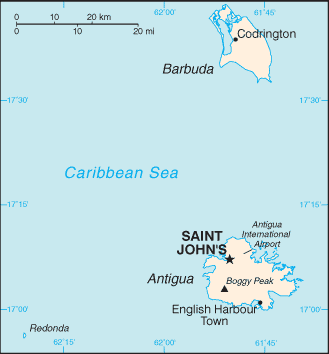
Antigua y Barbuda son islas que se encuentran entre el Mar Caribe y el norte del Oceano Atlantico. Al sur estan las islas de Monserrat y Guadalupe, y al norte y oeste estan las islas de Nieves, San Cristobal, San Barts, y San Martin.
Antigua es hacerca de 14 millas de largo y 11 de ancha la cual tiene un total de 108 millas cuadradas. Barbuda tiene una area de 68 millas cuadradas y esta como a 30 millas al norte de Antigua.
English
Caribbean Countries
Caribbean Map
Antigua Flag
Map of Antigua
Español
Paises del Caribe
Mapa del Caribe
Bandera de Antigua
Sources
https://www.cia.gov/library/publications/the-world-factbook/geos/ac.html
https://www.cia.gov/library/publications/the-world-factbook/maps/maptemplate_ac.html
http://www.antigua-barbuda.org/index.htm
Otras palabras claves usadas son mapa Antigua, map of the Caribbean, mapas Antigua, y Antigua mapas.
Regresar de mapa de Antigua to Antigua information
Regresar a paises del Caribe
Enjoy this page? Please pay it forward. Here's how...
Would you prefer to share this page with others by linking to it?
- Click on the HTML link code below.
- Copy and paste it, adding a note of your own, into your blog, a Web page, forums, a blog comment,
your Facebook account, or anywhere that someone would find this page valuable.
|


